THE 2002 TUNGUSKA MEASUREMENTS
 To complete the data collected by the Tunguska99 expedition
two Bologna researchers, Romano Serra and Maurizio
Serrazanetti, have gone to the Tunguska explosion
site (July 19-30, 2002). The Italian researchers have
been assisted in their work by Gennady Andreev, Larissa
V.Pavlova, John
Anfinogenov and Maria Shvedova, from Tomsk State
University and from Tomsk Polytechnic University. The
supplementary 2002 data refer to 1) magnetic field
intensity measurements, 2) verification of reference
points co-ordinates, 3) new data on surviving
and flattened trees, 4) peat sampling, 5)
iridium content in the Cheko lacustrine sediments
and in the ground of the Cheko shore.
To complete the data collected by the Tunguska99 expedition
two Bologna researchers, Romano Serra and Maurizio
Serrazanetti, have gone to the Tunguska explosion
site (July 19-30, 2002). The Italian researchers have
been assisted in their work by Gennady Andreev, Larissa
V.Pavlova, John
Anfinogenov and Maria Shvedova, from Tomsk State
University and from Tomsk Polytechnic University. The
supplementary 2002 data refer to 1) magnetic field
intensity measurements, 2) verification of reference
points co-ordinates, 3) new data on surviving
and flattened trees, 4) peat sampling, 5)
iridium content in the Cheko lacustrine sediments
and in the ground of the Cheko shore.
1) Magnetic field intensity measurements.
To perform the magnetic field intensity
measurements a Geometrics G-858 portable Cesium Magnetometer,
which uses a graphical interface to make survey design
and data acquisition quick and efficient, has been used
(see photo).
The G-858 was interfaced with a standard portable computer.
A solar
battery charger USF-11
was necessary because the Tunguska explosion site is
located at some hundreds kilometres from the nearest
roads. The magnetic field intensity measurements were
performed on the lake Cheko and its shore along 12 radial
directions around the maximum depth point (see red lines
on the photo).
2) Verification of reference points
coordinates.
Complementary on-site measurements
have been carried out to obtain the co-ordinates of
different reference points in the explosion area. These
data will allow to recognize ground elements on the
aerial pictures and to connect them to the regional
topographic net. The geographical co-ordinates of important
points on the itinerary Cheko-Kulik's izba-Churgim-Khusma
have been measured with a 3-5 meter resolution using
a GPS
system. An important result obtained in 2002 is
the correction
of Mount Farrington astro-radio point
co-ordinates. These co-ordinates, measured in 1929 using
astronomy and radio time signals, have been used in
all the works up to now. The new measurements (60°55'00",8
N; 101°56'56",0 E) show that they contained an error
of about 60 meters, both in latitude and in longitude.
3) New data on trees.
Surviving trees. On
the shores of the lake Cheko there are some tenths of
trees surviving the 1908 explosion. Many larches and
some spruce are still growing at a distance of a few
to some tenths of meters from the lake shore (see yellow marks
on the photo). Some tree older than one hundred years
show an anomalous
directional growth of the rings following those
of 1908 and 1909, thus witnessing the occurrence of
phenomena that caused the tree inclination. Many trees
surviving the catastrophe show a chaotic character and
an irregular distribution of the tracheids of the 1908
ring. This ring has often an anomalously
clear late wood characterized by narrower cells
with thinner walls. Sections and cores of these trees
have been collected to study the direction of the blast
wave around the lake.
Flattened trees. The
data on the azimuths of flattened trees have been obtained
from on-site measurements performed by V. Fast and co-workers
60-70 years after the 1908 explosion. We have now checked
and completed these data measuring the azimuths of fallen
trees as seen 30 years after the explosion. These new
data were taken from Kulik's 1938 aerophotosurvey, that
has been compared with the
new aerophotosurvey
performed by the Tunguska99 expedition.
To check some discrepancies between these data, complementary
on-site
measurements have been performed in 1999 and 2002.
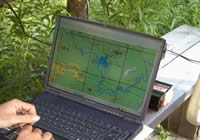
4) Peat sampling.
Surface peat samples from nine different
swamps (see map) have been
collected to study their anomalous high Cs-137 content.
To check our previous
results a supplementary column of peat
(red mark on the map) has been extracted
from the same place as the KEM N21 peat column taken
in 1999.
5) Iridium content.
The study of Cheko lacustrine sediments,
extracted in 1999, was extended to the ground of the
Cheko shore in 2002. For this purpose, a trench has
been excavated nearby the lake (see blue square
on the map). From the trench, 79
samples of the ground up to 167 cm depth have been packed.
The group of Dr. Christian
Koeberl (University of Vienna, Department of Geological
Sciences) has searched these samples for Iridium
and other related cosmic markers. The analyses were done
by instrumental neutron activation. Samples were counted
repeatedly after irradiation (for about three months)
and counted for a duration of up to four days on a high-efficiency
high-resolution HpGe detector.
Similar analyses on 110 samples of
Cheko lacustrine
sediments have been carried out by the team of Dr.
Eric Robin in the CEA/CNRS Laboratoire des Sciences
du Climat et de l'Environnement.
Other laboratories were involved in this work, but the results obtained are still contradictory.
|
)
)
)
)
)
)
)
)
)
)
)